MULGA DOWNS FIRE - NOVEMBER 2006
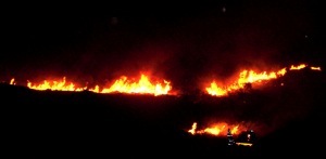
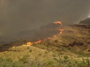
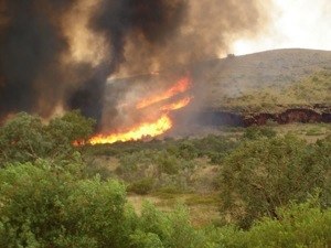
The Mulga Down fire in November 06 burnt for approximately 9 days and ended up covering a total of approximately 530sq kms (53,000 ha). The fire was started by lightning and rapidly grew in size threatening the road house and communications tower at Auski. The fire burnt both side of the highway and traveled in all directions over the period. Mulga Downs pastoral station is adjacent to and crosses the Great Northern Highway to the north of Karijini National park. It is a beautiful station with excellent pastures and many head of cattle.
Weather conditions at the time during the day were 40º – 43º with a humidity level of around 7%. Winds were variable to all points of the compass, causing the fire to travel in many different directions. Wind speed varied from still to 25 –30 kms per hour. A constant threat during this and other fires in the Pilbara fire are the amount of willie willies that develop in the hot windless period of the day generally between 1000hrs and 1500hrs daily. At one stage the fire had almost been contained with one small head fire burning slowly to the west. A willie willie hit and this fire was split into 9 separate fires near the Old Broome Road on the station. From that point on things went down hill.
The appliances on site were one slip on unit, one 1500lt trailer slip on, a grader and eventually three bulldozers. Several small fire breaks were installed to no effect. A 20 km break, running north to south, was cut using a grader and a bulldozer. Over night the fire jumped the break an continued to burn west. A 9km second fire break four bulldozer widths, also north to south, was constructed approximately 10 km east of the homestead. A 6km third fire break was then constructed east to west and linked to the 9km break. In the late afternoon the wind, which had been an easterly, turned north easterly and by- passed the fire breaks, traveling south west till it reached the Auski-Wittenoom Road to the south. The fire then became uncontrollable and was allowed to continue to burn until it hit natural barriers destroying a vast area of grazing land.
As well as then burning to the west, the fire jumped the road and got into the Karijini National Park and started a separate fire. This fire also headed to the west and finally burnt out some 5kms to the east of Wittenoom. There are still approximately 5 people still living in the town. The photos of this fire shows the fire coming over a ridge and the effect of a northerly wind in increasing the intensity of the fire and creating fire whirls which then ran up hill at right angles to the head fire.
Tony Taylor